Overview
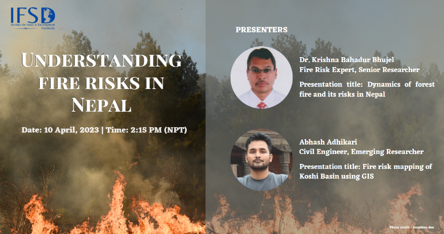
On April 10, 2023, the Institute for Study and Development Worldwide (IFSD) held a knowledge sharing session to discuss forest fire risks in Nepal, with presentations by Dr. Krishna Bhujel, a senior researcher, and Mr. Abhash Adhikari, an emerging researcher. The session was kept intimate, with only a few members of the IFSD team in attendance. This is one of the many sessions that IFSD plans to organize to facilitate co-learning between senior and emerging researchers, providing a platform to share knowledge on a particular topic.
The session was moderated by Priyanka Gurung, Research and Program Officer and Dr. Hemant Ojha, Principal Advisor, both affiliated with IFSD.
Presentations
Presentation 1: Fire risk mapping of Koshi Basin using GIS
Mr. Abhash Adhikari shared his findings based on fire risk mapping study in the Koshi Basin, which was based on land use and land cover data. He emphasized the importance of fire risk mapping in identifying potential fire hazards and adopting ways to mitigate risk. He mentioned that while Geographic Information System (GIS) plays a critical role in data analysis and visualization, it is a time-consuming process, and therefore the study focused only on the Koshi Basin. He noted that data on fire incidents from February 2012 to June 2016 was obtained from the Moderate Resolution Imaging Spectroradiometer (MODIS), which was available at The International Centre for Integrated Mountain Development (ICIMOD), and data related to land was acquired from the Irrigation Master Plan 2019.
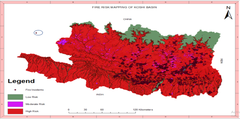
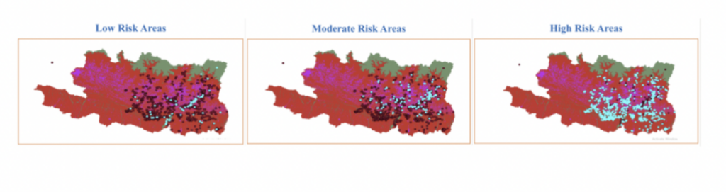
To develop a fire risk model, he used land cover as an independent variable and fire incidents and burned area as dependent variables. He has categorized land area based on their coverage and use and assigned different risk values to each category in relation to fire incidents and burn area, based on existing research. Forest, grassland, and shrubland areas were classified as high risk, agricultural and built-up areas were classified as moderate risk, while water bodies and barren land were classified as low risk (presented in the figure below). The fire risk model was validated through testing and refinement, and compared to existing data sets, aligning with the original assumptions, that land cover and land use affects fire risks.
He further acknowledged that while his findings provided insights into fire risk, there are other factors that should also be considered in assessing risk.
Presentation 2: Dynamics of forest fire and its risk in Nepal
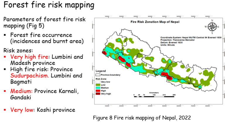
Dr. Krishna Bhujel provided insights into forest fire trends in Nepal, highlighting opportunities to mitigate forest fire risks. He reported that MODIS data from 2001-2022 showed an increasing trend of forest fires in Nepal, with an annual average of 2.65 million hectares burnt and 2,896 incidents per year. His findings showed that most forest fires occurred in April and the pre-monsoon season, with a gradual increase during winter as well. Likewise, the Tarai and Siwalik regions had the most fire incidents per square kilometer, and tropical mixed hardwood forests saw the highest number of fires. He added that through fire risk mapping on a provincial basis, Lumbini and Madesh are identified as very high-risk zones, Sudurpaschim, Lumbini, and Bagmati as high-risk zones, Karnali and Gandaki as medium-risk zones and Koshi as low-risk zone (presented in the figure below). These findings were consistent with existing research.
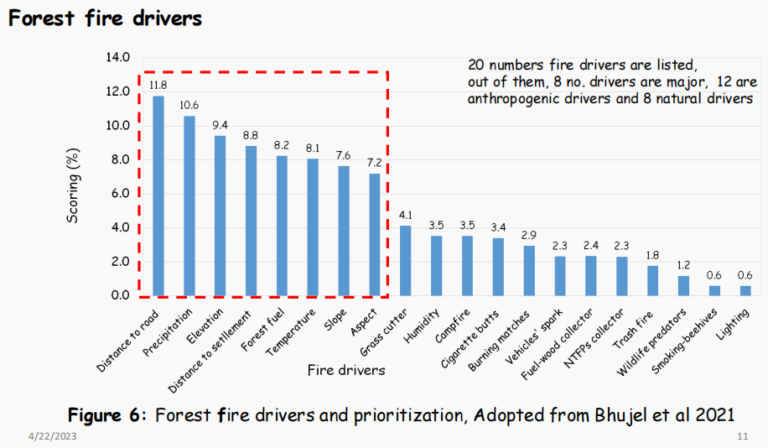
The rapid increase in forest fires can be attributed to various drivers. He conducted a study in the Tarai region, which identified 8 major drivers of forest fires. Of the 20 drivers considered, 8 were natural and 12 were anthropogenic, indicating the significant impact of human activities on forest fires (presented in the figure below). Given the significant potential loss of forests, biodiversity, and even human life, it is crucial to mitigate fire risks. Further, he emphasized the importance of transitioning towards sustainable fire management and suggested immediate and long-term actions to achieve this goal. In the immediate term, he recommends capacity building and raising awareness through local media, reducing forest fuel by removing combustible materials (especially coarse fuel), applying active forest management before the active fire season, conserving water resources in forests for fire extinguishing purposes, and creating safe zones for settlements.
For the long-term, he recommends managing fire extinguishing equipment through community user groups, constructing and maintaining fire lines, promoting community-based fire management practices, establishing forest fire alert systems, promoting the use of non-forest fuel sources, establishing a fire database system, and conducting research through academic institutions in collaboration with concerned ministries. In both the immediate and long-term, he focused on involving local communities and governments and encouraged strong coordination and communication with local authorities.
Lastly, he highlighted the importance of research in improving our understanding of forest fires, as limitations in research have hindered progress in this area. He suggested several areas for research focus, including developing models for forest fire behavior, assessing the impact of forest fires on forest ecosystems, biodiversity hotspots, non-timber forest products, air pollution, soil properties, and estimating biomass and carbon loss in different forest types. He also emphasized the need to assess the impact of climate change on forest fires. Concluding his presentation, he shared images of forest fires in Nepal to highlight the urgency of the issue.
Discussion session moderated by Dr. Hemant Ojha
1. Hemant Ojha: Abhash, you modeled fire risk based on land cover type, then you used the actual data of fire incidents from ICIMOD to validate the model and identified that land cover affects fire risk? Alleviation aspect exposure and many other factors contribute to that as well so what is the significance or message of your findings?
Abhash Adhikari stated that he had taken only one factor into consideration, explaining that the lengthy processing time of GIS had limited his analysis. He acknowledged that other factors, such as altitude and slope, also affect fire risk, but incorporating them would have reduced the accuracy of the model due to the large quantity of data involved. He briefly described his research process and agreed that the ultimate knowledge outcome of the process was model validation and generating new insights.
2. Ramu Subedi: How compatible are the categorizations you have used with land use categorizations done by the Nepal Government?
Abhash Adhikari mentioned that did not use the classifications done by the Nepal Government and only used data from Irrigation Master Plan 2019. The survey done for Irrigation Master Plan 2019 was conducted around 2016 which closely aligned with the data he had available. As a result, he decided to use the classifications from the Irrigation Master Plan 2019 in his analysis.
3. Ajay Adhikari added that the Irrigation Master Plan 2019 had taken into consideration the classification done in the recent National Land Use Project and incorporated other aspects in relevance to irrigation, so the classification to some degree aligns with the one done by the Nepal Government but not completely.
Dr. Bhujel recommended that along with land cover and land use, there are many factors that equally contribute to fire risk. So, creating layers and merging them could lead to a more accurate understanding of this issue. He acknowledged that this process is time-consuming but emphasized that developing a more inclusive model would be preferable.
Abhash agreed with Dr. Bhujel and added that the process for fire risk mapping in GIS for other factors is identical to the one he presented.
4. Ajay Adhikari: There is a general impression mainly in the water resources sector, that when there are incidences of forest fire, in the following monsoon there appears to be an increase in floods as well. So, an area for future research could also be the impact of forest fire on floods and how much loss and damage impact floods have. What do you think?
Dr. Bhujel stated that his study had focused primarily on tropical forests in the Tarai region, where surface fires result in minimal loss and damage. However, he acknowledged that the points raised would be relevant for future research.
5. Ajay Adhikari: In my opinion, the forest fires in the hilly region have an impact on the flood intensity and occurrence in the Tarai region, looking into that might be fruitful?
Dr. Bhujel acknowledged that it would be a good area to conduct further research.
6. Ramu Subedi: Firstly, from Nepal’s total carbon emission perspective, how much do forest fires impact carbon emission, how much tentative share does it have in the country’s carbon emission? Do we have any figures on that? Secondly, in terms of fire incidences and types of regimes, do we have anything that shows the relation between the two, for example, community forest having less fire incidents, is there anything like that management-wise in the last 20 years?
Dr. Bhujel mentioned that while there are no figures or data on the impact of forest fires on carbon emissions in Nepal, but some studies were being conducted by students. Previously, REDD had attempted to conduct a study in the past, although it is unclear what the outcome was. Nevertheless, understanding the impact of forest fires on carbon emissions is crucial in the current context. While smaller studies cannot be definitive, the ones conducted so far suggest that the impact of forest fires on carbon emissions in Nepal is minimal. He noted that community-based fire management is more effective in plain areas. In some areas like Manang, the terrain makes it difficult to access the location of fire incidents and increases the extent of damage caused by fires. However, in places where access is possible, community-based firefighting groups have been established, and conservation efforts have been implemented within forest areas, serving multiple purposes. Therefore, it is crucial to promote community-based fire management. To his knowledge, no relationship has been observed between fire incidences and types of regimes, as comparative studies have not been conducted on this topic.
7. Basundhara Bhattarai: Forest fires have a significant impact on both the environment and living being, while there is limitation of data in the context of Nepal, there is an understanding that this is something that needs more attention. How is our state’s response mechanisms and resources when it comes to forest fire management since most of the forests are controlled by the state?
Dr. Bhujel responded that that a 2022 study found that the budget allocation for forest fire management is minimal. However, in terms of structural response, the Department of Forests and Soil Conservation, in partnership with ICIMOD, has established a forest fire desk that has been operating for the past 2-3 years. It serves as an information hub and is connected to fire alert systems. Additionally, at the community and district levels, where there are more funds available, seasonal fire groups have been established and provided with training, equipment, vehicles, and seasonal access to water. However, such efforts are not present at the province and state levels. It is essential to collaborate with local governments and communities to address forest fires effectively.
8. Abhash Adhikari: So, when we assign value during fire risk modeling based on research, for example, I found that particularly, broad-leaved closed forests were very high risk, and broad-leaved open forest was low risk, will that be accurate even when multiple studies have the same findings?
Dr. Bhujel stated that despite assigning values while conducting research is important, there are many other factors such as the structure of the tree, the type of tree that also contributes to forest fire. So, relying on and using only assigned values are not ideal, as it can reduce the accuracy of the assessment.
9. Hemant Ojha: As we have now gotten an understanding of forest fire risks, management and gaps in Nepal, there seems to be a need for accountability. Even when we do not consider climate change, fire risk and incidents persist because people are not taking the actions that they need to so how can we go about strengthening accountability system?
Dr. Bhujel suggested that strengthening local governance might have a positive impact on accountability at governance level as progress cannot be made without involving government institutions. Therefore, moving forward in partnership where the community takes the lead could be a better solution.
Conclusion
Forest fires is a pressing issue in Nepal which requires immediate attention, as the trend is increasing and current efforts to address it are inadequate. This session offered valuable insights into forest fires in Nepal, covering fire risks and their mapping, trends and impacts of forest fires, as well as challenges and opportunities for addressing the issue. While there are gaps and limitations at both the research and governance levels, collaborative efforts are necessary for effective forest fire management.
How to cite this report: Banjade, P., Gurung, P., Bhujel, K., and Adhikari, A. (2023). Understanding fire risks in Nepal: A Report summarizing the event proceedings and outcomes. IFSD internal knowledge sharing session (Virtual, 10 April 2023), Institute for Study and Development Worldwide (IFSD), Sydney, Australia.
Download PDF version of the report.